Beyond the palace gates | What your Pena Palace map is really telling you

Pena Palace isn't just one building; it's a whole world to explore. Between the colour-soaked palace across two floors, the sprawling Pena Park, the Queen's Terrace, and the High Cross viewpoint, your Pena Palace map is your best travel companion here.

Pena Palace map

Pena Palace map showing routes to Cruz Alta, Chalet of Countess of Edla, and Pena Farm.

Navigating the Pena Palace & Park

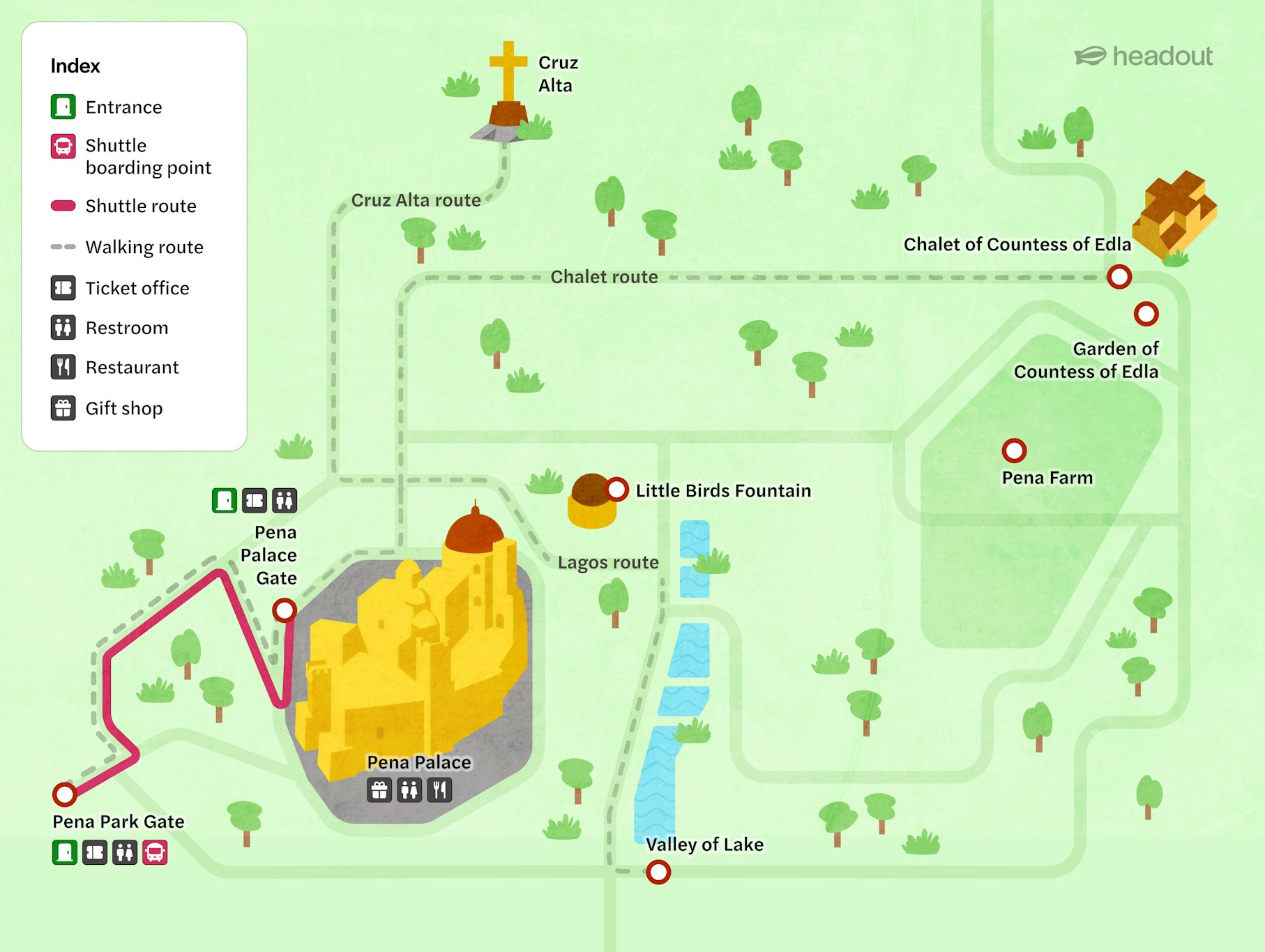
The main entrance opens into Pena Park, a dense, forested buffer zone before the palace itself. From the park gate, you can either walk uphill (25–30 minutes) through winding trails, or hop on the paid shuttle bus that runs from the lower entrance to the palace gates.

Once you reach the palace, most visitors naturally move:

  • Moorish Terraces & outer walls → great for photos and orientation
  • Palace interior (Ground + Upper Floor) → state rooms, royal kitchens, the Arab Room, and the Queen's bedroom
  • High Cross Viewpoint → the highest point in Sintra, with sweeping views over the palace and the Atlantic
  • Eateries & rest stops → near the palace entrance for a quick coffee or snack

How long will you need? Budget 2 to 3 hours if you're doing the palace + highlights of the park. If you want to explore the park trails deeply, add another hour.

Visitor facilities

Pena Palace has the essentials covered. And if you're the plan-ahead type, you can download a Pena Palace map PDF from here or the official park mobile app before your visit.

  • Restrooms — Available near the palace entrance and at the lower park gate. Expect a short queue during peak hours (late morning on weekends).
  • Accessibility & ramps — The park trails and some palace areas have uneven, cobbled surfaces. Wheelchair users should note that full interior access is limited; staff at the entrance can advise on the most accessible route.
  • Shuttle service — A paid shuttle runs between the lower park entrance and the palace gate, a lifesaver if steep uphill walks aren't your thing.
  • Café & snack bar — Located just outside the palace entrance. Great for a mid-visit coffee or a light bite before tackling the park trails.
  • Gift shop — Near the palace exit, stocked with Sintra-themed souvenirs, prints, and books.
  • Information point — At the main palace gate, where staff can answer questions and hand out printed maps of the grounds.

Must-see highlights

Placeholder Image Headout Blimp

The palace exterior & terraces

The riot of red and yellow walls, turrets, and gargoyles that make every photo look unreal. Start here to get your bearings and your best shots.

Placeholder Image Headout Blimp

Visitor tips for exploring Pena Palace

  • Download the map before you go: The park's Wi-Fi is patchy at best. Grab the Pena Palace map PDF or screenshot it, so you're not squinting at a paper fold-out near the shuttle stop.
  • Arrive early, start from the top: Take the shuttle up first thing in the morning, explore the palace, then walk downhill through the park at your own pace, stopping at the Valley of Lakes and Little Birds Fountain on the way down.
  • Pick up the more detailed Pena Palace Park map at the entrance kiosk: The trail junctions inside the park aren't always clearly signposted. A physical map from the kiosk is worth grabbing even if you have the digital version. The park is bigger than it looks, and it's easy to miss hidden gems like Fonte dos Passarinhos.
  • Use the Pena maps zone markers to plan your route: The map divides the grounds into clear zones: palace area, upper park, lower park, and the Chalet garden. Decide which zones matter most to you before you enter, so you're not backtracking uphill after a long walk down.

Frequently asked questions about Pena Palace map

You can pick one up at the main entrance kiosk or the information point near the palace gate. Staff are helpful and can also point you toward the lesser-visited trails.